Mild and Wet - cool start, becoming progressively warmer. A number of very wet days
March was fairly settled for the first week, being dry and quite cool with frosts common, but the weather broke down quite significantly from the 9th with the first of two very wet 48 hour spells.
After a drier and more settled interlude mid month, it again became unsettled from the 23rd with the second very wet 48 hour period coming 27-28th, which saw some very significant falls in the LDNP. The final two days of the month saw high pressure re-asserting itself and with a southerly flow that brought a very warm end to the month.
After that the cool start, the gradual progression to milder conditions saw the month finish warmer than average and the four very wet days were enough on their own to ensure a wetter than average month.
March 2021 now shares a curious record with December 2015 in that it is the only month in which there has been two occasions with an inch of rain recorded on consecutive days. In many ways it was a mixed month, terrible at times, a few good days, especially at both ends of the month, but one that never really got going.
Whilst here at Maulds Meaburn an inch of rain was recorded on four days, just down the road at Appleby there was ... none!
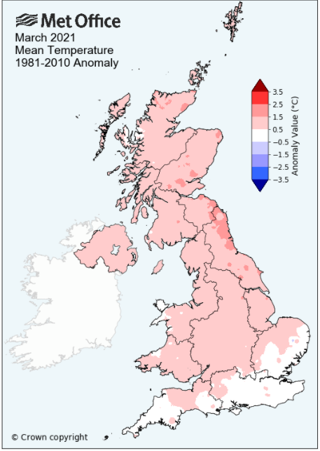
MSLP of 1019.5 Mb was +7.0 MB above the local average for the month and overall a mean minimum of 2.66°c and a mean maximum of 9.97°c saw the temperature 0.98°c above the twelve year average for this site.
It was the warmest since 2017 and of the thirteen now recorded, three have been warmer, eight have been colder and one was the same - the highest maximum temperature recorded being 18.8°c (31st), the lowest minimum -4.1°c (6th).
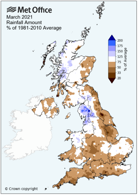
Rainfall of 161.1 mm (Maulds Meaburn North 156.8 mm -- Castlehowe Scar 211.5 mm) was 190.7% of average for 2008-20 and made it the wettest March since 2019. Of the fourteen now recorded, one has been wetter and twelve have been drier.
During the month the following was recorded: snow/sleet fell on three days (5th, 13th and 25th), hail on three days (11-12th and 26th) and there was fog on one day (18th) -- The wind speed averaged 8.03 mph, with a maximum gust of 54 mph (10th), with two days having gusts in excess of 50 mph.
At the Met' Office site at Newton Rigg a mean temperature of 6.46°c is 1.1°c warmer than average and is the warmest since 2017. In a series back to 1952, 59 have been colder and 10 have been warmer.
Rainfall totalled 120.0 mm (158.3% of average), making it the wettest since 2019. Since the record began in 1900, 10 have been wetter and 110 have been drier (1 year with no data - 1950).
At Appleby in Westmorland a total of 107.2 mm represented 176.9% of its average (1857-2020) and made it the wettest since 2019 - in a record that commenced in 1857, 15 have been wetter, 147 drier and 2 have had the same total.
Rainfall totals across Cumbria were above average although out on the coast some of the percentage falls were closer to the average, with St. Bees being one of the few exceptions, having just 89.5% of its average. Many locations, principally within the LDNP, did see in excess of 150% but with some equally heavy daily falls the central eastern portion of Cumbria experienced the largest positive departures from the norm�. This saw Shap (311.6 mm) record 195.2% of its average, but it was just down the road at Orton (297.0 mm) where the highest percentage fall (228.6%) was recorded and the only location which went above 200%.
And whilst it was broadly the wettest March since 2019, at Shap it was the wettest since 1994.
Figures from the Environment Agency�s rainfall sites were, (figure in brackets being the monthly average for 1961-90) �Data kindly provided by the Hydrometry and Telemetry team of the Environment Agency (Penrith)�:
Kirkby Thore 77.2 mm (55.1 mm)
Haresceugh Castle (Kirkoswald) 83.79 mm (84.6 mm)
Brothers Water 403.34 mm (219 mm)
Orton (Shallowford) 297.0 mm (128.0 mm [average for 1967-2019])
578.8 mm at Seathwaite Farm (Borrowdale - 319 mm [average for 1981-2010]) - making it the wettest since 2019 and the sixth wettest in a record that commenced in 1845.
General Synoptic Report for the Month
The high pressure (HP) that had brought a dry and settled end to February remained the dominant feature at the start of the month and continued the dry, sunny theme, but now with night-time frosts. Apart from the 5th, the first seven days of the month all saw air frosts, but day-time temperatures were a little bit more complex.
With the 1st and 2nd being calm and enjoying cloudless skies and plenty of sunshine, the temperature rose accordingly, 13.0°c on the 1st was followed by 12.6°c on the 2nd, but the 3rd - 6th saw a notable dip in daytime maxima. The 3rd started chilly with a frost of -3.7°c and whilst it would also be sunny, there was a nagging, if slight, cold easterly wind allowing for a maximum of just 5.9°c. A weak cold front pushing down from the north brought a cloudier day on the 4th with a little drizzle, but behind this front, HP that had been over Greenland, moved south, sitting over Scotland on the 5th.
This introduced an E-NE'ly flow and for the 5-6th it was cloudy and cold. Both days only recorded a maximum of 4.6°c and the 6th also recorded the month's lowest temperature of -4.1°c (24.6°f).
During the 7-8th the HP slipped away south and now a succession of low pressure (LP) systems would bring a period of unsettled and wet weather through to the 15th. By the 9th the HP was just hanging onto southern England but with LP west of Eire pushing a frontal system towards the UK - the rain arrived in the evening, fell heavily overnight to give 25.8 mm (credited back to the 9th) and then after the briefest of lulls, a new system brought more rain (32.4 mm) during the second half of the 10th and overnight into the 11th.
With that rain came strong and gusting winds, mainly during the evening of the 10th and overnight into the 11th. A maximum gust of 54 Mph was recorded on the 10th, followed by 53 Mph on the 11th -- both the 9th and 10th had recorded over an inch of rain, this being the sixth occasion in my records when consecutive days had recorded such - it was all rather unrelenting and lousy.
Other two days falls on the 9-10th included: Brampton 20.0 mm -- Grasmere 93.1 mm -- Honister 193.6 mm -- Shap 94.8 mm -- Orton 82.6 mm
Those strong winds came on the southern flank of the LP as it moved NE to the west of Eire and once east of Iceland it became semi-static and responsible for a brisk, showery and slightly cooler W'ly flow. In that flow some of the showers over the next few days fell as hail or sleet.
A new area of LP during the evening of the 12th brought another 14.9 mm of rain, but the 'Azores High' had slowly been pushing north, partly creating that W'ly flow between it and the LP near Iceland and gradually it would start to dominate.
The high was west of Spain 14th, in Biscay 15th and then west of Eire 16th where it would then park itself for the next few days. This had the effect of settling the weather down and we now had a period of dry, slightly warmer weather and with enough glimpses of the sun to offer a little cheer.
Daytime temperatures were into double figures, peaking with 14.8°c on the 18th (the sun coming out after a foggy start), but a few weak fronts from the east did occasionally bring cloudier conditions at times. However, it was remaining dry and the ground was steadily drying out.
The HP remained to the west of Eire through to the 20th when it began to slowly slip south, although remaining the dominant feature of our weather. The 22nd saw it move back NE to lay off the Normandy coast, before retreating into Europe 23rd and which now allowed a cold front to pass over the UK from off the Atlantic - the weather would now turn unsettled and wet.
LP systems would be dominant through to the 29th and within the period we endured yet another very wet 48hrs. The 23rd-26th was very mixed, experiencing periods of rain (although tending to be in the evening or overnight), the odd brighter moment and some hail on the 26th when it fell a little cooler - it would be the 27-28th when it became really grim.
With a deep area of LP in the central, north Atlantic and the HP in Europe, there was a strong SW'ly flow and frontal system associated to the LP arrived during the evening. That frontal system took a leisurely stroll across the UK and with a new wave developing behind the initial fronts, the rain just kept coming.
The rain started to fall at 20h on the 27th, would become heavy at times and would not cease until 07h 29th - this saw 28.6 mm fall on the 27th with a further 31.7 mm 28th - this being the seventh occasion in my records when consecutive days had recorded such - and following Dec' 2015, the second occasion with two such events in the same month!
Other 48hr falls included: Appleby 31.7 mm -- Grasmere 178.4 mm* -- Honister 259.6 mm+ -- Shap 145.6mm -- Orton 143.6 mm
In the 24 hours ending at 0900 GMT on the 29th, 177.2 mm of rain fell at Seathwaite � the highest 24hr fall in the UK during the month.
* included 130.2 mm on 28th
+ included 159.4 mm on 28th
And the miserable nature continued on the 29th - whilst only recording 0.4 mm of rain, it was grey, dank and windy, with heavy drizzle on and off all day. However, the HP over Europe was starting to ridge back over the UK and whilst eastern parts of the UK had enjoyed a fine day on the 29th, Cumbria had a little longer to wait.
The 30th started in the same vein of murky, dank conditions, but by late morning had brightened up and 'the afternoon turned out quite nice'. The HP brought a warm southerly flow to the UK and the 31st would become the month's warmest day with 18.8°c (65.8°f) and after a morning of hazy sunshine, was also quite pleasant through the afternoon.
Rainfall totalled 161.1 mm for the month, with rain recorded on 16 days of which 13 were 'Wet days' (1.0mm +).
The Mean Temperature for the month was 6.32°c -- The Mean Max' was 9.97°c -- The Mean Min' 2.66°c.
We had 6 Air Frosts in the month (year 35) -- Grass Frosts totalled 13 (year 52).
The 1 foot soil temp ranged from a low of 4.4°c on the 7th to a high of 9.0°c on the 31st -- with a monthly mean of 6.4°c
The 1 meter soil temp ranged from a low of 5.9°c on the 8th to a high of 7.6°c on the 31st -- with a monthly mean of 6.5°c
JANUARY 2010
FEBRUARY 2010
MARCH 2010
APRIL 2010
MAY 2010
JUNE 2010
JULY 2010
AUGUST 2010
SEPTEMBER 2010
OCTOBER 2010
NOVEMBER 2010
DECEMBER 2010
JANUARY 2011
FEBRUARY 2011
MARCH 2011
APRIL 2011
MAY 2011
JUNE 2011
JULY 2011
AUGUST 2011
SEPTEMBER 2011
OCTOBER 2011
NOVEMBER 2011
DECEMBER 2011
JANUARY 2012
FEBRUARY 2012
MARCH 2012
APRIL 2012
MAY 2012
JUNE 2012
JULY 2012
AUGUST 2012
SEPTEMBER 2012
OCTOBER 2012
NOVEMBER 2012
DECEMBER 2012
SUMMER 2012
REVIEW OF 2012
JANUARY 2013
FEBRUARY 2013
MARCH 2013
APRIL 2013
MAY 2013
JUNE 2013
JULY 2013
AUGUST 2013
SEPTEMBER 2013
OCTOBER 2013
NOVEMBER 2013
DECEMBER 2013
REVIEW OF 2013
JANUARY 2014
FEBRUARY 2014
MARCH 2014
APRIL 2014
MAY 2014
JUNE 2014
JULY 2014
AUGUST 2014
SEPTEMBER 2014
OCTOBER 2014
NOVEMBER 2014
DECEMBER 2014
WINTER 2014
REVIEW OF 2014
JANUARY 2015
FEBRUARY 2015
MARCH 2015
APRIL 2015
MAY 2015
JUNE 2015
JULY 2015
AUGUST 2015
SEPTEMBER 2015
OCTOBER 2015
NOVEMBER 2015
DECEMBER 2015
REVIEW OF 2015
JANUARY 2016
FEBRUARY 2016
MARCH 2016
APRIL 2016
MAY 2016
JUNE 2016
JULY 2016
AUGUST 2016
SEPTEMBER 2016
OCTOBER 2016
NOVEMBER 2016
DECEMBER 2016
REVIEW OF 2016
JANUARY 2017
FEBRUARY 2017
MARCH 2017
APRIL 2017
MAY 2017
JUNE 2017
JULY 2017
AUGUST 2017
SEPTEMBER 2017
OCTOBER 2017
NOVEMBER 2017
DECEMBER 2017
REVIEW OF 2017
JANUARY 2018
FEBRUARY 2018
MARCH 2018
APRIL 2018
MAY 2018
JUNE 2018
JULY 2018
AUGUST 2018
SEPTEMBER 2018
OCTOBER 2018
NOVEMBER 2018
DECEMBER 2018
REVIEW OF 2018
JANUARY 2019
FEBRUARY 2019
MARCH 2019
APRIL 2019
MAY 2019
JUNE 2019
JULY 2019
AUGUST 2019
SEPTEMBER 2019
OCTOBER 2019
NOVEMBER 2019
DECEMBER 2019
REVIEW OF 2019
JANUARY 2020
FEBRUARY 2020
MARCH 2020
APRIL 2020
MAY 2020
JUNE 2020
JULY 2020
AUGUST 2020
SEPTEMBER 2020
OCTOBER 2020
NOVEMBER 2020
DECEMBER 2020
REVIEW OF 2020
OTHER ARTICLES
The Oldest Inhabitant
An Inch Of Scotch Mist
But it's meant to be Summer (Summer 2017)
© Darren Rogers 2010-21
Want to comment on this site? email